-->
:
:
CANARY ISLANDS- ISLAS CANARIAS- KANARISCHE INSELN | |||||||||||||||||||||||||||||||||||||||||||||||||||||||||||||||||||||||||||||||||||||||||||||||||||||||||||||||||||||||||||||||||||||||||||||||||||
BLOG/ Startseite
FEBRUARY 03- 09 2014
| |||||||||||||||||||||||||||||||||||||||||||||||||||||||||||||||||||||||||||||||||||||||||||||||||||||||||||||||||||||||||||||||||||||||||||||||||||
 |
Activity report here will ony follow, if new events take place. For other environmental reports, please visit the solar and terrestrial blog on my homepage
-----------------------------------------------Activity reports- 3.- 09. February 2014:---------------------Sunday, February 09 2014/:/ 21:45 UTC
the next one: with M 2.1 a little bit stronger, but still from a depth of 12 km:
Saturday, February 08 2014/:/ 21:45 UTC
MICROQUAKES / MAGMA INTRUSION BELOW EL HIERRO:
TREMORS:
Tremors are at low level and were relatively strongest on Gran Canaria and the eastern islands Fuerteventura and Lanzarote
 < Gran Canaria/ 24 h plot/ 20140208 < Gran Canaria/ 24 h plot/ 20140208
-------------------------------
Friday, February 07 2014/:/ 18:45 UTC
MICROQUAKES / MAGMA INTRUSION BELOW EL HIERRO:
one minor microquake today:
TREMORS: Tremors after this microquake that stands for any magma movement or magma boost are relatively strongest on la Gomera and Gran Canaria:  < La Gomera 24 hour plot / 20140207 < La Gomera 24 hour plot / 20140207HEAT SIGNATURE ( By MODVOLC/ Hawaii thermal alerts) No changes in intensity so far since February 12:  ---------------------------- Wednesday- February 04- 05- 2014/last update/ 10:00 UTC:
Microquake activity below of Le Hierro has intensified on February 06, suggesting any magma movement below the island Its also possible, that new Magma intrusion from the hot spot below Hierro into the old Caldera or an assumed (new?) large magma chamber somewhere below the islands continues. Here the third "hic hoc" today- this time below the eastern side of El Hierro.
Evento
Fecha
Hora(GMT)*
Latitud
Longitud
Prof.
(km)
Int. Máx.
Mag.
Tipo Mag. (**)
Localización
Info
1257055
05/02/2014
08:42:26
27.7212
-18.0189
11
1.8
mbLg
NW EL PINAR.IHI
| The 3 d quake model, scientist made made from the microquakes in the Yellowstone caldera- shows so the researchers- not any magma chamber, but the form of the mantle plume, that usually opens upwards like a funnel. On the 3 D Modell of El Hierro, the signature of the microquakes would indicate , that this mantle plume opens into South- south eastern direction: This is very interesting, because it would mean nothing else, that if there is any second deeper and intact magmachamber below the caldera on which the Canary island actually sit , it would be in direction to the Marrocean coast. (read more below) last update: 09 UTC:MICROQUAKES / MAGMA INTRUSION BELOW EL HIERRO:

DEFORMATION:
Deformation has also resumed on El Hierro and lifted up the island again for several cm during the last days so reports the El Hierroblogspot on February 03- 2014
TREMORS: Tremors increased again a bit on February 05 on La Gomera, Gran Canaria and the eastern islands of Lanzarote and Feurtevenura, but are rather low on the plots posted on the IGN website.  <24 hours CTIG plot/ 20140205 ( El Hierro as posted by IGN) <24 hours CTIG plot/ 20140205 ( El Hierro as posted by IGN)volcano-discovery.com however shows an on hour plot for February 05 6- 7 UTC of the La Fontera, on which the seismic activity seems to be rather tubulent:  ----------------- Monday- February 03- 2014/ 09 UTC:
No further quake below El Hierro yet today. Seismographs on El Hierro, La Palma, and Tenerife show weaker harmonic tremor.
La Gomera , Fuerteventura und Lanzarote have stronger tremor signals (at time of this update) Gran Canaria is turned off
 < La Gomera/ 20140203 < La Gomera/ 20140203 < Tenerife/ 20140203 < Tenerife/ 20140203
-----------------------------------
--activity reports end--
----------------------------------------
What does the 3 D Model of the quakes below El Hierro (since 2011) really display? The 3 d quake model, scientist made made from the microquakes in the Yellowstone caldera- shows so the researchers- not any magma chamber, but the form of the mantle plume, that usually opens upwards like a funnel. On the 3 D Modell of El Hierro, the signature of the microquakes would indicate , that this mantle plume opens into South- south eastern direction: This is very interesting, because it would mean nothing else, that if there is any second deeper and intact magmachamber below the caldera on which the Canary island actually sit , it would be in direction to the Marrocean coast.This is were also I strongly suggest, that the original Magma chamber ( which is now collapsed to the caldera on which the Canaries sit today) most likely was part of a real supervolcano that was attacked to the africa coast. Any time this volcano must have had a magma chamber eruption ( bouyancy effect )which destroyed most of the volcanic structures also on the Marrocean coast, but has left giant a imposant remnants and layers of a size that suggest the former existence of a supervolcano there, with its center in the region of Tifnit/ South of Agadir ( find more about this theory below.Most Canary islands ( except Fuerteventurea and Lanzarote, that once broke off from the African coast) might have been at this time random volcanoes those had already formed in this period around egde around the big shield of the main supervolcano and where surely sverely shaken but ginally spared by that destructive last magmachamber eruption
Normally a caldera then poses not much danger anymore . Its just like a broken cup, filled with fragile materials, through whih magma likely can flow out into all direction, but where even with the presence of water steam and gases no sufficiant pressure can built up anymore that could carry the magma up to the surface.
YELLOWSTONE- THE SUPERVOLCANO MODEL WITH TWO MAGMACHAMBERS: BUT: Also the Yellowstone caldera has- so researchers- most likely two magma chambers: an upper one which is regularly formed and destroyed with surface activities and eruptions . But there might be ( and this is the modell Us volcanologists finally made of the YS magma chamber) a second deep magmachamber below, that remains intact even while it moves with the drift of the tectonic plates and Earth crust and through periods with surface eruptions. And this could also be the case with the Canary hotspot !
Also if media programs sometimes suggest that science today can "do everything," its not possible to localise to survey and monitor such a magma chamber in this depth of more than 8- 10 km with any means today!
So the factor and alert level UNKNOWN remains- especially for the Canary islands!!
here again the excellent documentary about the research on the Yellowstone caldera : ------------------
----------------
THIS WEEK`S SUBJECT:
HISTORY OF THE CANARY ISLANDS
. This week I want to start a kind of historical review: I have read some sources yet, but will , while doing this, also by myself search read more detailled reports about the history of the Canaries.
When does history begin, if not at that time, when these islands have been created by the same volcanic forces in the depth, those now- millions of years later are still there ? However, before any human being lived on the Canaries, the islands had a geological history I want first refer to and report about. In the left frame you find some public works and theories by Spanish and German geologists about the Canary hotspot
I myself here want rather refer to the "unconventional" theories:
WERE THE CANARIES ONCE ATTACHED TO THE AFRICAN COAST?
There is good evidence for a theory saying , that the Canary Island once were directly attached to the African coast and tectonic plate. While the everage depth of the Atlantic is about 5000 meters, the seaground around the C. is a common plateau reaching up to an average of 3.700 meters below zero, which is covered with a thick layer of sediments, brought along mainly by the sea currents- that no research of ths islands basement is possible or has not been done yet. Possibly that what we see today are just the mountain peaks of one former larger island. Also the cycladic island were once one island that sank deeper into the ground ( maybe when the common magmachamber of the former supervolcano collapsed? The difference is: LOts of human structures were found in between the islands ( where not even diving is allowed) wjat means nothing else than: this event must have been not so long ago
next images: Coastal " break of zones" on Lanzerote, Fueteventura and near Tifnit( Maroc)? ( images: google)

^lanzarote ( Northeast coast

^coastal "breakof structures" in the NORTH East of Fuerteventura

^coastal "breakof structures" in the NORTH WEST of Lanzarote
compare: Fuerteventura has no such breakoff structures on its Northwest coast:

Break of structure on the Coast of Maroc near Tifnit

here another map:
(click on images to enlarge them) I have made this model just to show, where and to see how the estern edge of the Canary atoll might - if so- once have been attacked to the West African coast. near today`s Agadir, where volcanic origin is harder to identify after human influence has meanwhile formed the landscape there. (I was also Agadir and remember tourist resorts all along the ciast there but can`t say anything about its formations)

.
( image above) Its just a theory! As I would say: The shapes Of Lanzarote however fit in pretty well in the shape off the african coastline there., while Fuerteventura fits well to the South of Lanzarote) For sure, erosion and sea currents must have erased some of the edges on both parts, but left the shapes rather intact. Any interpretation is up to the eyes of the beholder!
"MAGMA CHANNELS" REACHING FROM THE CANARY HOTSPOT INTO AFRICA? "
Some expert out of any reason even suggested that there might be "magma channels " from the El Hierro hot spot below El Hierro to the next African volcano group in the South of Algeria more than 1.500 km to the West . And I myself could even image there might be a complete under world below our feet in a depth of more than 10 km we just can`t explore by any means! ( the deepest hole ever yet was drilled by BP in 2009 in the Gulf of Mexico wuith a total depth of about 13.000 meter below sealevel) : More about that in my next weeks blog!
But why - I am just asking me -should take the magma from the hot spot below El Herro take such a long way through any old and most likely partially collapsed "magma channels" and erupt then anywhere in more than 4000 meter height in the Atlas mountainsof Algeria?
. Its just like with all fluids: They take the easiest way they find, they way with the less RESISTANCE!
--------------------------------------------------
VOLCANIC LAYERS BY A FORMER SUPERVOLCANO ON THE NEARBY COAST OF MAROC, but no volcano all around
( except the nearby Canaries) On a three month journey through Marooco I have seen myself evidence that support that theory: remnants of large volcanic structures can be found on the African Atlantic coast in are area around 100 km South of Agadir / Marroc near the town of Iznit. There is an Eucaylyptus forest that end at a long wide bay and beach with light sand , yet untouched by tourists To the right end of that bay , a large massive coastal rock with thick layers of volcanic material reminds on intensive volcanic activity there and regulary eruptions those must have occured thereover a longer periode of time.
But not any volcano (except the nearby Canary islands) is there all around in a distance of at least 500- 1000 kilometers!
to be continued below:
I did not explore the entire region South of Agadir nor have I been not at the formost southern point to where thes volcanic structures can be found and I have unfortunately no pictures from that place.
I could not find pictures of that specific bay withg kts black magma layers in the www yet
But the regions has more volcanic structures those are same expressive .
 arcs near Tiznit ( Marocco, South of Agadir) arcs near Tiznit ( Marocco, South of Agadir)
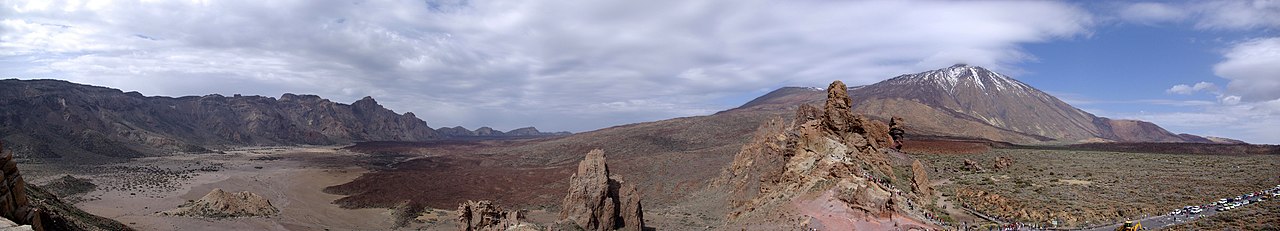
SIMILAR TYPES OF VOLCANIC MATERIAL IN "LAS CANADAS DEL TEIDE":
The extremely hard red (hot spot) lava of these arcs as well as the rather fragile black magma of the layers ( form upper magma chambers) are identical with the two types volcanic material that can be found on all Canary islands and especially in the heights of the large former Mnt teide crater:
 
however, as the following images show; the type and color of material ejected from the Teide volcano there has changed with the time:

< Canadas Del Teide (click here to visit the website where I found that image with excellent photographies also from other natural resorts on this globe)
to be continued from above :what I have seen on this beach about 120 km South of Agadir is in all just a small remnant of a larger volcanic structure with layers, formed by eruptions- about 1/2 to 1 meters thick and by the size comparable to the volcanic layers those can be found in the Eifel volcano field. The volcanic layers seemed - so far as I remember that place- to decline into Southestern direction, what means that the former volcano crater that producrd these laywers must have been to the Northwest ( rather Northwest)
What makes that place so strange is, that this coastal formations with its layers end up so abruptly as a brakeoff towards the sea,. All looks alike that the main part of these structures those formally led further into the sea must have broken off there and kind of dissapeared in the sea. Whats is left is a volcanic scenery that looks still as if the catastrophy just would have happened yesterday.
what might have happened there ?
The idea I got when I was on this empty beach there for three days and when saw these scenery daily was that of an ultimate eruption , after which the former supervolcano caldera in the depth might have collapsed , what had the consequence that the remaining parts of that peninsula broke off there from the mainland, slipped southwards into the sea and settled afterwards again some further in the SW and deeper within the sea.
Does any of these old supervolcanoes (resp their calderas) really still pose a thread today?
However: the remnants of those supervolcanoes shows that these systems once had extensions over hundreds of kilometers, when the Earth was still hotter on the surface as well as in its core, That all these volcano systems- as well as the hot spots those feed them- still exist todays and are still active today DOES NOT MEAN, that these volcanoes would still be able to produce eruptions of that size as it was the case hundreds of Million years ago.
was either a global earthquake catastrophy as reported by several ancient sources around 10.000- 5.000 BC, At time were almost no records of a human civilisation or traces were found, and when -as the church believes- no humans even had existed and Adam and Eve were not created yet.
appendix:
---
more images from volcanic structures in the Bay of Agadir, Southern Maroc, between Agadir and Dakla ( source: Google Earth)                 .----------------------
--------------------------------
next weeks subject:THE CANARY ISLANDS IN MYTHOLOGY------------------------remarks about this blog:
Ich habe beschlossen den Blog, bzw. zumindest die aktuellen Berichte in englischer Sprache fortzuführen. Mit Englisch lässt sich das alles einfacher kürzer und genauer ausdrücken. Deutsch ist besser zu verwenden für Dichtkunst oder um Geschichten zu erzählen,. Außerdem kann der Blog dann von mehr Menschen gelesen werden. Natürlich können Kommentare weiter in deutsch oder anderen Sprachen verfasst werden
This blog does not intend to give scientific advice or analysis. Its just wants to document the ongoing volcanic activity and the real events how they envolve, what might serve also as a basic for own conclusions.
Recently I decided to continue this blog - at least the activity updates and report- generally in English language. My English might not be perfect, but at least better than an automatic translator.Its easier to express anything in English than in German and it makes the blog easier understandable for international users. Special stories might be written in German. Comments can be posted in all languages, I recommend to use English, so comments are understandable for the most international visitors ---- some remarks about this blog: Generally also want to refer in this blog also to other interesting aspects of the Canaries, many people might not know yet. But- currently I want to document here the new and unexpected volcanic activity that began in 2011 , that has for itself many aspects, worth to review and tell about ---------
------------------
| |||||||||||||||||||||||||||||||||||||||||||||||||||||||||||||||||||||||||||||||||||||||||||||||||||||||||||||||||||||||||||||||||||||||||||||||||
letztes Beben(Kanarische Inseln ( IGN)  Bebenmap( El Hierro)  ^ MODVOLC/ Hawaii thermal alerts near real time thermal alert for El Hierro, la Palma, Teneriffe and la Gomera ( updated once per week) ------- --------------- previous weeks posts: January 15- 19- 2014 January 20- 27- 2014  Mnt Teide ( Teneriffe) related free online sources:VOLCANOES: "Eruptions that shook the world" a very interesting and freely avaible source how volcanoes work where you find all what you want to know about volcanoes Sources of the volcanic activity at El Hierro ( since 2011): Some may like to read a review on the volcanic activity below El Hierro in 2011: Here is a data based report by earthquake .com- an excellent site regularly reporting (what you never get in the news) about Earthquakes and related volcanism worldnews.com: Special environmental reports about the Canaries Miscanellous: Geschichte Teneriffas (deutsch)   Fataga ( Gran Canaria) San Cristóbal de La Laguna in 1880 (Tenerife)  Caldera de Taburiente National Park (La Palma).  Garajonay (La Gomera)  (BBC/ 20111204)Canary Island volcano: A new island in the making? PUBLIC AVAIABLE ESSAYS AND WORKS ON THE GEOLOGICAL HISTORY OF THE CANARY ISLANDS: Hotspot volcanism close to a passive continental margin: the Canary Islands J. C. CARRACEDO*†, S. DAY†, H. GUILLOU‡, E. RODRÍGUEZ BADIOLA§, J. A. CANAS¶ & F. J. PÉREZ TORRADO by the same authors: The Canary Islands: an example of structural control on the growth of large oceanic-island volcanoes nature.com/ scientific reports: The origin of the Canary Island Seamount Province - New ages of old seamounts deutsch: Kanaren-Hotspot speiste Atlas-Vulkane 1.000 Kilometer langer Tunnel unter Nordwest-Afrika (Rainer Olzem, Diplomgeologe). Der Kanarische Hotspot - Hypothesen zur Entstehung der Kanarischen Inseln | |||||||||||||||||||||||||||||||||||||||||||||||||||||||||||||||||||||||||||||||||||||||||||||||||||||||||||||||||||||||||||||||||||||||||||||||||||

:
Keine Kommentare:
Kommentar veröffentlichen