-->
:
:
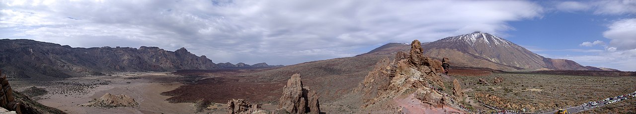
CANARY ISLANDS- ISLAS CANARIAS- KANARISCHE INSELN | ||||||||||||||||||||||||||||||||||||||||||||||||||||||||||||||||||||||||||||||||||||||||||||||||||||||||||||||||||||||||||||||||||||||||||||||||||||||||||||||||||||||||||||||||||||||||||||||||||||||||||||||||||||||||||||||||||||||||||||||||||||||||||||||||||||||||||||||||||||||||||||||||||||||||||||
BLOG/ Startseite
MAY 01- 31- 2014
| ||||||||||||||||||||||||||||||||||||||||||||||||||||||||||||||||||||||||||||||||||||||||||||||||||||||||||||||||||||||||||||||||||||||||||||||||||||||||||||||||||||||||||||||||||||||||||||||||||||||||||||||||||||||||||||||||||||||||||||||||||||||||||||||||||||||||||||||||||||||||||||||||||||||||||||
 |
Activity report here will ony follow, if new events take place. For other environmental reports, please visit the solar and terrestrial blog on my homepage
------------- ACTIVITY REPORTSMAY 27 - 28 2014: one magmatic quake on May 28 off the Southwestern coast of El Hierro:

as already previouisly mentioned, any of these magmagic quakes generally only indicates the presence and current depth on a magmatic intrusion by the resistance , possibly uprising magma still meets in the underground. But as more hot magma accumulates in the underground as lower would become this resistance ( in form of not yet not molten solid rocks) . So, neither the magnitude nor the frequency of these magmatic quakes are an really reliable source how much magma is actually coming up or how intensive this flow is.
same with tremor signals those are best describale as vibrations or friction effects, caused by the heat in the undergournd itself and by gases such as steam those expand byx the heat in the magma deposit and surge upwards through volcanic fissures and channels,
TREMORS:
The Tremor signals on El Hierro increased again over the last days, and are currently as high as at the begin of the new activity at the end of 2013:
 Allthough EL Hierro is for sure the current location of the mantle plume resp the hot spot where magma surges upwards form the earth mantle into the large canary caldera , the intensity of tremors is lowest. The reason is: where the mantle plume ends up in appr 11 km depth is no water , resp can exist no water in fluid form due to the usela temperatures in that depth, The heat is highest there but heat alone does not create these tremors . it nedeed gases - mainly steam to create the temproarely strong vibrations those can be observed on the canaries since the hot spot activity resumed in 2011. Allthough EL Hierro is for sure the current location of the mantle plume resp the hot spot where magma surges upwards form the earth mantle into the large canary caldera , the intensity of tremors is lowest. The reason is: where the mantle plume ends up in appr 11 km depth is no water , resp can exist no water in fluid form due to the usela temperatures in that depth, The heat is highest there but heat alone does not create these tremors . it nedeed gases - mainly steam to create the temproarely strong vibrations those can be observed on the canaries since the hot spot activity resumed in 2011.
< ^ El Hierro/ 20140530
steam and resulting tremors is therefor only produced in more shallow depths resp.from within the caldera between th islands, where the magma currently flows to from the mantle plume below El,Hierro . The strongest emssions and tremors however since begin oif the activity phases in 2014 was measured not near El Hierro but on Teneriffe and Gran Canaria:
however: Also Tremor signals there have increased during the past days again to those highest levels those where observed since January 2014:
 < GRAN CAN/ 20140531 < GRAN CAN/ 20140531
Tremors signals on Teneriffe are some weaker and more harmonic:
 < Teneriffe/ 20140531 < Teneriffe/ 20140531
HOW BIG IS THE RISK OF AN EXPLOSIVE SURFACE EVENT?
rather low as also I just can guess, as long as magmatic quakes don`t happen in morre shallow depth what is currently and since 2013 not the case . in other words updewlling maga has enough space there to fill typical cracks fissures and holes in the Earth crust those typically form out in continental stretching zones such as the entire Atlantic is. Earthquake from more shallow depths such as < 5 km and less would be a serious indicator for an upcoming surface eruption or event . But no such earthquake was measured yet since the first an only surface eruption late in 2011 resp since the activity resumed on 2013.
 as all observation show, the magma from the mantle plume seems currently ( resp since 2012) all to flow into that large caldera , the former primary Canary shield volcano has left when its magma chamber collsapsed after a last explosion and eruption in historical times. Due to the usual evolution of shield volcano systems and in respect of the suggested but barely known continental plate movements in this region during past millenium , this huge primary shield and supervolcano once was situated somewhere in between the todays islands ( which formed as secondary shield volcanoes on the edge of the primary one). Thus that Caldera today must be centered somewhere in the South between La Gomera, Gran Canaria and Teneriffe. as all observation show, the magma from the mantle plume seems currently ( resp since 2012) all to flow into that large caldera , the former primary Canary shield volcano has left when its magma chamber collsapsed after a last explosion and eruption in historical times. Due to the usual evolution of shield volcano systems and in respect of the suggested but barely known continental plate movements in this region during past millenium , this huge primary shield and supervolcano once was situated somewhere in between the todays islands ( which formed as secondary shield volcanoes on the edge of the primary one). Thus that Caldera today must be centered somewhere in the South between La Gomera, Gran Canaria and Teneriffe.
El Hierro is the latest secondary shield volcano the hot spot has created with its hot and fluid gasless magma. not very long ago as it semes since it is known, that the mantle plume and hot spot are still near in the Southeast the islands and the oceanic crust has not drifted very far since then
As any other caldera als the Canary one is best describable as a kind of broken pot with lots cracks and fissures and holes , an environment in which not much pressure can built up for an explosive event as long as the magma does not form ( by an following process of magma intrusions those harden out and create so an new shale resp. new enclosed magma chamber. As long as this is not the case just some steam emissions , ( in some regions also surface geyser) and most seldom really lava flows are the only expectable volcanic activities in those systems.
 <(wikipedia) Diagram of a shield volcano, showing the multiple layers of lava flows in a mature shield volcano <(wikipedia) Diagram of a shield volcano, showing the multiple layers of lava flows in a mature shield volcano
more links:
Shield volcanoes (BBC) ...... Shield volcanoes (USGS)....(livescience) Volcano Facts and Types of Volcanoes
----------------- MAY 24 - 26 2014: one magmatic quake below the sourthern part of El Hierro in 12 km depth on May 26.:

TREMORS:
Seismographs had been shut down , had a malefunction - but most likely just the plots were not published during the past 3 days. Plots on the IGN website resumed today ( May 27) and show increased tremors on all islands including La Palma. As usually, tremors are still relatively strongest on Gran Canaria:
 < Gran Can/ 20140527 < Gran Can/ 20140527
MODVOLC thermal alerts show still an unchanged picture with heat discolorisations on the highest peaks of all islands ( except Fuerteventura and Lanzarote) . likely caused by hot gases surging up form the deep magma deposit) The heat signature is still strongest all around the peak and crater region of Mount Teide on Teneriffe. Also the "cumbre viecha" on La Palma shows still stronger red colorisation around the main crater and towards the Eastern parts of the volcano chain sinde the latest reviews:
 < MODVOLC/ 20140527 < MODVOLC/ 20140527
For comparation: MODVOLC thermal image / previous month:
 MODVOLC/ 20140427 MODVOLC/ 20140427 Other news: A stronger single quake occured on the midatlantic ridge near to the Azores ilsands on May 26- 2014:( report by< EMSC). The quake was subseas and there were no reports that it was felt on any of the nearby azores islands or to which phenomenon the quake might be related to. I myself would imagine it was caused by a magmatic boost through the Atlantic ridge. M 5.0 - AZORES ISLANDS REGION - 2014-05-26 19:43:14 UTC    Google Earth KML Google Earth KML------------- MAY 22 - 24 2014:one quake on May 24. Depth: unknown:
 TREMORS:
Tremor plots are unavailable on the IGN Website now since more than 3 days .
Only the El Hierro plot with its usually relatively weak signals is still online....

SPECTROGRAM / EL HIERRO/ 20140526

---------------
MAY 19 - 21 2014:
Two quakes on May 20 and 21- both again on the fault line between Teneriffe and Gran Canaria
 TREMORS
continue on lower pace and are still strongest on Gran Canaria:
  DEFORMATION DATA/ EL HIERRO/ APRIL- MAY 2014: DEFORMATION DATA/ EL HIERRO/ APRIL- MAY 2014: there was a stronger magma intrusion that caused a further lift up at the end of the first week in May 2014 The lift up was - as it seems stronger on the NORTHERN part of El Hierro while the Southern part just showed the usual dynamic up and down fluctuation related to the ongoing activities. The island remained stable since then on that new height. there was a stronger magma intrusion that caused a further lift up at the end of the first week in May 2014 The lift up was - as it seems stronger on the NORTHERN part of El Hierro while the Southern part just showed the usual dynamic up and down fluctuation related to the ongoing activities. The island remained stable since then on that new height. ----------------------MAY 16- 18 2014
two minor magmatic quakes were registered on May 17 on El Hierro:
Tremor plots were no available at the time of this update
Other news: A seldom but now stronger earthquake occured on May 18, 2 km South of Darmstadt/ Germany near to the Eifel volcano field, another sleeping supervolcano, that became some more active in the recent years (see map)

EMSC has yet two reports form darmstadt, where the quake was felt on the surface: -----------------MAY 13- 15 2014May 15: One quake form a depth of 10 km from below the center of El Hierro:
 ----------------MAY 11- 12 2014
Two minor quakes in the last two days. The latest ocurred on a new site, some 20 km off the coast of Southern La Gomera in just 1 km depth. ( its part of the old large caldera to where the magma from the mantle plume below El Hierro currently flows to>:

Tremors remained equal during the past days and are still elavated
There are no deformation data yet available for May 2014 on the IGN website.
Earthquake strength on the Azores islands also increased to values above M 4.0 during the past days: M 4.2 - AZORES-CAPE ST. VINCENT RIDGE - 2014-05-11 13:46:39 UT ------------------- MAY 09- 10 2014
new magma intrusion seems to have set in below El Hierro as expected , Now three minor quakes in two days- all in a depth of 11 km:
Tremors increased on May 10 on all islands. ( La Palma seems to be turned off)  < Gran Can < Gran Can  >La Gomera >La GomeraThere is no significant change on the recent MODVOLC thermal images ------------------- MAY 07- 08 2014
One minor quake from untold depth , located again on the fault between Gran Canaria and Teneriffe, where now regularly about 5 minor quakes took place during the past two months:
 -----------------------MAY 06 2014
One minor quake from a depth of 11 km with the epicenter on the southeastern end of El Hierro - a first indicator for ta new magma intrusion as expected late after the last solar proton event:. Please note, that the strength and frequency of those magmatic quakes does not necessarily allow to draw interferencies to the strength of the related magma intrusion!
As it could be observed already during the recent magma intrusions, the coincident earthquake swarm near Puerto Rico also resumed at the boundary of the Carribean plate to the Atlantian spreading zone . This swarm quakes are likely caused by magma flows from the El Hierro hot spot and/ or from somewhere else such as fissures within the Atlantic stretching zone , capable to cause some pressure on tectoncic plates through the strong (gravitational9 expansion forces, magma envolves when rising up from the earth mantle in an average depth 30 km and more:
the last quake there measured even M 4.7 what is even one of the highest values since the earthquake swarm there accomponies the periodical magma intrusions from the El Hierro hot spot.
 
Tremor again increased slightly on all islands and is as usually strongest of Teneriffe and Gran Canaria Some electric distortion effects as being an by effect througout this activity phase is again visible on the seismograph on Gran canaria

----------------
MAY 01 2014 (first update)
an M 2.7 quake occured early on May 2 on the Western boundary of Lanzarote, Magma from the Hot spot below El Hierro howver seems not flow further than to Teneriffe and Gran Canaria ,two island, those those once formed at the edge of an old huge Canary shield volcano and remained stable on the rim when this shield volcano in historical time collapsed to today`s old caldera.
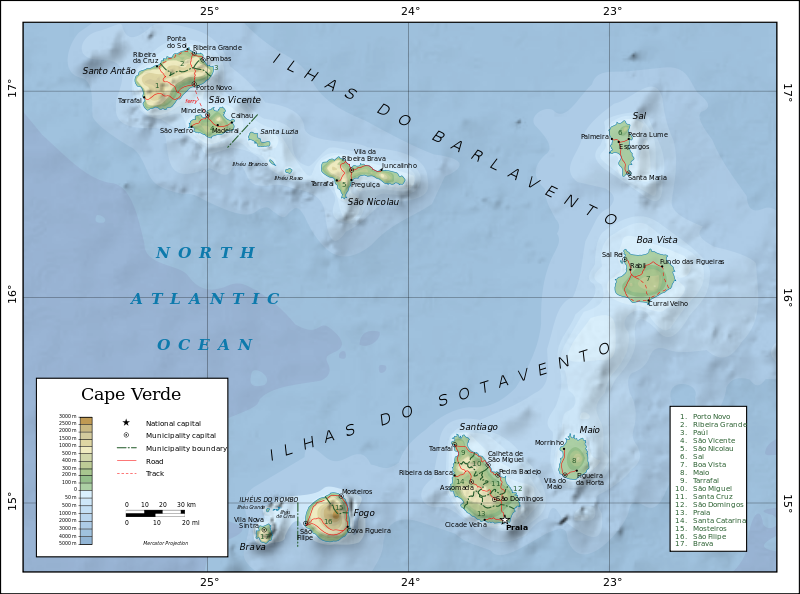 Allthough magma flow from El Hierro seems mainly to be limited within the old Caldera , also the archipelagoes North (Azores) and South ( Cape verdes islands) of the Canaries have volcanic origine , but they were likely not been formed by the Canary hot spot but rather by fissures and trenches those formed out along the african coast as in all so called sretching zones (compare: iceland). I will next time try to find some informations aboiut the Azores and post it here. Allthough magma flow from El Hierro seems mainly to be limited within the old Caldera , also the archipelagoes North (Azores) and South ( Cape verdes islands) of the Canaries have volcanic origine , but they were likely not been formed by the Canary hot spot but rather by fissures and trenches those formed out along the african coast as in all so called sretching zones (compare: iceland). I will next time try to find some informations aboiut the Azores and post it here.<<<Cape verdes island (wikipedia)
Quakes are rather frequent also on the Azores, which is partially in the subduction zone between Eurasia and Africa : These frequent quakes with their average magnitudes around M 3 are usually not regarded as dangerous or even effective But also activity there increased in the recent years, what could also be an indicators for magmatic intrusion along with geological activities on a wider scale. Representators of both archipelagos however also attended the recent conferences held on the Canaries to elaborate plans how to get on with a possible volcanic surface eruption or catastrophy on the islands especially on the Northern flank of Mnt. Teide.
 -------------------MAY 01 2014:
The > 10 MeV electron flux is still knocked down by active protons, while >0.8 < 2.0 MeV Electron flux is - as usual - not that much reacting on that and recovered already on May 01
 No significant quake activity below El Hierro was registered since APril 26 , while tremors below El Hierro are still on an elevated level since April 23, which are quite the same as tremors were on in January 2014, after a new activity phase had started in late December 2013.  This indicates that hot magma is still below the island and as the few minor quakes from and average depth of 11 km show ( those are just indicators that there is still any resistence down there - might be as rocks resp. likely magma that hardened out after a previous intrusion) that magma indeed has risen up higher since then . Allthough there was not such quake now since about one week , also a minor magma intrusion might be still going on. Deformation data have not been updated yet but show the last graph shows , the island remained stable during the past weeks Also, the red color on the 1- 2 Hz range of the Spectrogram is interprated such, that hot magma is active below the island:  Tremors however are strongest on Cran Canaria followed by Tenerife :  < Tenerife 20140501 < Tenerife 20140501 < GRanCan/ 20140501 < GRanCan/ 20140501------------------- | | ||||||||||||||||||||||||||||||||||||||||||||||||||||||||||||||||||||||||||||||||||||||||||||||||||||||||||||||||||||||||||||||||||||||||||||||||||||||||||||||||||||||||||||||||||||||||||||||||||||||||||||||||||||||||||||||||||||||||||||||||||||||||||||||||||||||||||||||||||||||||||||||||||||||||||
REAL TIME FEATURES:
(click on the images to enlarge them)  Bebenmap( El Hierro)  GPS deformation measure stations on El Hierro  MODVOLC/ Hawaii thermal alerts: ^ near real time thermal alert for El Hierro, la Palma, Teneriffe and la Gomera ( updated once per week) volcano discovery. com : Earthquake within 30 km radius around El Hierro: 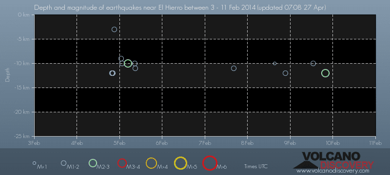 ------- --------------- previous posts those contain articles about the Canary volcanism in general:February 10- 16- 2014 January 15- 19- 2014 January 20- 27- 2014  Mnt Teide ( Teneriffe) related free online sources:VOLCANOES: "Eruptions that shook the world" a very interesting and freely avaible source how volcanoes work where you find all what you want to know about volcanoes Sources of the volcanic activity at El Hierro ( since 2011): Some may like to read a review on the volcanic activity below El Hierro in 2011: Here is a data based report by earthquake .com- an excellent site regularly reporting (what you never get in the news) about Earthquakes and related volcanism worldnews.com: Special environmental reports about the Canaries Miscanellous: Geschichte Teneriffas (deutsch)  Fataga ( Gran Canaria)  San Cristóbal de La Laguna in 1880 (Tenerife)  Caldera de Taburiente National Park (La Palma).  Garajonay (La Gomera)  (BBC/ 20111204)Canary Island volcano: A new island in the making? | ||||||||||||||||||||||||||||||||||||||||||||||||||||||||||||||||||||||||||||||||||||||||||||||||||||||||||||||||||||||||||||||||||||||||||||||||||||||||||||||||||||||||||||||||||||||||||||||||||||||||||||||||||||||||||||||||||||||||||||||||||||||||||||||||||||||||||||||||||||||||||||||||||||||||||||