-->
letztes Beben(Kanarische Inseln ( IGN)

Bebenmap( El Hierro)

GPS deformation measure stations on El Hierro

MODVOLC/ Hawaii thermal alerts:

^
near real time thermal alert
for El Hierro, la Palma, Teneriffe and la Gomera ( updated once per week)
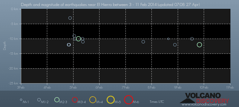
volcano discovery. com : Earthquake within 30 km radius around El Hierro:
-------
---------------
February 10- 16- 2014
January 15- 19- 2014
January 20- 27- 2014

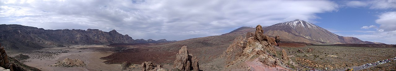
Mnt Teide ( Teneriffe)
VOLCANOES:
"Eruptions that shook the world"
a very interesting and freely avaible source how volcanoes work where you find all what you want to know about volcanoes
Sources of the volcanic activity at El Hierro ( since 2011):
Some may like to read a review on the volcanic activity below El Hierro in 2011:
Here is a data based report by earthquake .com- an excellent site regularly reporting (what you never get in the news) about Earthquakes and related volcanism
worldnews.com: Special environmental reports about the Canaries
Miscanellous:
Geschichte Teneriffas (deutsch)

Fataga ( Gran Canaria)
San Cristóbal de La Laguna in 1880 (Tenerife)

Caldera de Taburiente National Park (La Palma).

Garajonay (La Gomera)

(BBC/ 20111204)Canary Island volcano: A new island in the making?
:
:
CANARY ISLANDS- ISLAS CANARIAS- KANARISCHE INSELN | |||||||||||||||||||||||||||||||||||||||||||||||||||||||||||||||||||||||||||||||||||||||||||||||||||||||||||||||||||||||||||||||||||||||||||||||||||||||||||||||||||||||||||||||||||||||||||||||||||||||||||||||||||||||||||||||||||||||||||||||||||||||||||||||||||||||||||||||||||||||||||||||||||||||||||||||||||||||||||||||||||||||||||||||||||||||||||||||||||||||||||||||||||||||||||||||||||||||||||||||||||||||||||||||||||||||||||||||||
BLOG/ Startseite
ACTIVITY/ SEPTEMBER 01- 30 2014
| |||||||||||||||||||||||||||||||||||||||||||||||||||||||||||||||||||||||||||||||||||||||||||||||||||||||||||||||||||||||||||||||||||||||||||||||||||||||||||||||||||||||||||||||||||||||||||||||||||||||||||||||||||||||||||||||||||||||||||||||||||||||||||||||||||||||||||||||||||||||||||||||||||||||||||||||||||||||||||||||||||||||||||||||||||||||||||||||||||||||||||||||||||||||||||||||||||||||||||||||||||||||||||||||||||||||||||||||||
 |
Activity report here will ony follow, if new events take place. For other environmental reports, please visit the solar and terrestrial blog on my homepage
------------- ACTIVITY REPORTS- SEPTEMBER 01- 30 2014SEPTEMBER 26- 30- 2014
a low magnitude earth quake from a depth of just 3 km was registered on September 29 at 16:48 in the center of valle de Golfo- which forms the remnant of the edge of a former shield volcano, resp. crater. Next days will show whether this was an isolated event, or in any sense a first serious approach of magma to the surface.

-----------------
------------------
SEPTEMBER 15- 25- 2014
magma intrusion below El Hierro seems to continue on the low level, it was already during the past months. The depth of the shockwaves was between 11 and 16 km.
--------------
-----
SEPTEMBER 11- 14- 2014
Lower activity during the past days with one minor magmatic quake below El Hierro with a depth of just 9 km- the most shallow quake measured there since begin of the activity phase end of 2013:
------------
------------------------------
SEPTEMBER 10- 2014NEWS ALERT:
Sep 90/ 10: Sudden dramatic increase in solar activity: Two strong flares ( one M 5 and one X 1 class ) within 48 hours
and new solar proton storm
This will rock!
I was just really kind of shocked when reviewing solar data after I had received today an email message reporting two sudden and strong strong solar X- flares those occured by th sudden within 48 hours after a more tghan half year of tranquility , that made most believe, that solar sun spot activity had decreased after its peak back in 2013-. What makes me a bit of "shivering "was/is the high amplitude this event shows in the X ray spectrum:

The second flare was ( > the expected SEP serial...) accomponied by another solar SEP ( proton event). This proton storm will again intensify global hot spot activities ( in the sense of intensifying magma intrusions) and raise the risk of eruptions as well as all the other multiple geophysical effects proton storm actually have. ( I just wanted to my default daily activitioes , but surely will update my solar blog soon : First of all, users of global networks such as GPS should be careful about radio blackouts the next days those can occure on satellite connections as well as in physical terrestrial cable networks. Also disturbances ( blackouts) may occure in parts of the high frequency band those are used for satellite based TV transmissions and other information services ( handy networks)
Today I first will make a video from the solar event .  new incrrease in integral proton flux, while the last one was just about to diminuish. new incrrease in integral proton flux, while the last one was just about to diminuish.---------------
--------------------
SEPTEMBER 07- 09 - 2014A slight increase in activity:
-----------------
-------------------
SEPTEMBER 06- 2014unchanged situation with increased activity on September 06- 2014
TREMORS:
Tremors are still very weak -with a low amplitude ( even on Teneriffe) but seem ( to me) to have a higher frequency ( what may be typical for hot magma??)
 DEFORMATION
There was at least no further liftup process on El Hierro in the past months until end of August 2014
There are no data yet about the deformation since begin of the new activity phase end of August 2014:
  SURFACE TEMPERATURE:
There is no big change in the thermal images of the four islands El Hierro, La Palma, Teneriffe and La Gomera, since I reviewed the images last time. : The colorisation of the volcano chain on La Palma ( cumbra vieja) seems to me to have a bit intensified:
-----------------------------------------
update for Barbadunga volcano/ Iceland:
after days of cloudy skies, NASAs Moderate Resolution Imaging Spectroradiometer (MODIS) was first time able to make a thermal image of the extent of the lava flow below resp. within the large Barbadunga caldera:
(by NASA/ MODIS):
Though photographers, seismologists, and automated webcams have been documenting the eruption near Iceland’s Bardarbunga volcano from the ground, satellite imagery has been scarce because of persistent cloud cover and a relatively small number of spacecraft that collect images at high latitudes. But in the past few days, NASA satellites have finally been able to observe the event from orbit.
At 12:45 p.m. Universal Time on August 31, 2014, the Moderate Resolution Imaging Spectroradiometer (MODIS) on NASA’s Aqua satellite acquired this false-color view of the eruption.. read more...
 ( NASA/ MODIS/ 20140905):
Early on September 5, the Icelandic Met Office reported two new fissures had developed south of the initial eruption site. The Moderate Resolution Imaging Spectroradiometer (MODIS) on NASA’s Terrasatellite captured this view of the eruption on September 5, 2014, at 12:50 p.m. local time. The red outline shows where MODIS detected unusually high surface temperatures associated with volcanic activity. A plume of gas and steam is blowing east.
“These two new fissures are closer to the Vatnajökull ice cap (just 2 kilometers north of its edge), so concern is growing larger than the eruption will start happening subglacially, potentially causing glacial outburst floods as the lava erupts under the ice,” wrote Denison University geologist Erik Klemetti in ablog post for Wired...read more...

estimated extent of the magma accumulation in the region lof the Barbadunga Caldera on S Aug 27- September 01/ 2014:
 < High-resolution composite of a natural-color observation from August 27 overlaid with an infrared (IR) night view from September 1. Image credit: Advanced Land Imager (ALI) on NASA’s Earth Observing-1 satellite < High-resolution composite of a natural-color observation from August 27 overlaid with an infrared (IR) night view from September 1. Image credit: Advanced Land Imager (ALI) on NASA’s Earth Observing-1 satelliteOther interesting news sources for updates on the Barbadunga eruption:-------------
--------------------------------
SEPTEMBER 05 - 2014:
two more magmatic quakes followed on September 04 and 05 the new increase of activity from the hot spot and mantle plume below El Hierro, that began on September 01:
 (remark: This hot spot activity- as also others- again resumed and increased after another solar SEP had occured on September 01- ( its a long duration event and the proton storm now last already 5 days) The first weak SEP on August 25 (likely the begin of a typical SEP serial) followed by the LED proton storm on Sep 01 was the first SEP (also called: " SAP or: "SPE" > solar accelerated protons/ solar proton event ) after an half year with no SEP at all. You find more about solar SEP in this blog page below . Latest informations and updates you find in my and terrestrial blog on my homepage )
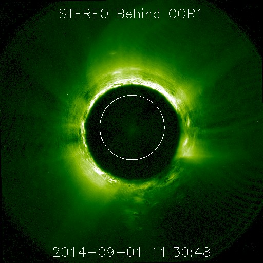
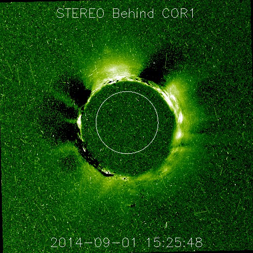
< img 1: 20140901/ after 11 UTC: its better to see on the movie than on this still picture: Beginning proton event . eruption near Northern Solar pole between 60 °- 90° latitude on earth facing side of the Sun. (on Stereo Behind. the earth stands at the right side of image)
imag 2: Particle flux some hours after the proton eruption took place: ( image: STEREO BEHIND/COR 1):
| ||||||||||||||||||||||||||||||||||||||||||||||||||||||||||||||||||||||||||||||||||||||||||||||||||||||||||||||||||||||||||||||||||||||||||||||||||||||||||||||||||||||||||||||||||||||||||||||||||||||||||||||||||||||||||||||||||||||||||||||||||||||||||||||||||||||||||||||||||||||||||||||||||||||||||||||||||||||||||||||||||||||||||||||||||||||||||||||||||||||||||||||||||||||||||||||||||||||||||||||||||||||||||||||||||||||||||||||||

| Evento | Fecha | Hora(GMT)* | Latitud | Longitud | Prof. (km) | Int. Máx. | Mag. | Tipo Mag. (**) | Localización | Info |
| 1293422 | 03/09/2014 | 23:15:20 | 28.1096 | -16.1286 | 27 | 1.5 | mbLg | ATLÁNTICO-CANARIAS | [+] | |
| 1293363 | 03/09/2014 | 22:35:56 | 27.7152 | -18.2199 | 16 | III | 3.8 | mbLg | W FRONTERA.IHI | [+] |
| 1293360 | 03/09/2014 | 19:53:36 | 27.7501 | -18.2133 | 33 | 2.4 | mbLg | W FRONTERA.IHI | [+] | |
| 1293351 | 03/09/2014 | 19:03:26 | 28.0353 | -16.1482 | 31 | 2.9 | mbLg | ATLÁNTICO-CANARIAS | [+] | |
| 1293013 | 02/09/2014 | 05:34:07 | 27.7324 | -18.0778 | 19 | 1.8 | mbLg | SW FRONTERA.IHI | [+] | |
| 1292642 | 31/08/2014 | 01:32:33 | 28.8844 | -16.8833 | 1.5 | mbLg | ATLÁNTICO-CANARIAS | [+] |
the M 3.8 quake on Sep 03 was also registered by EMSC. EMSC registeres quakes worldwide form a magnitude of M 4 on and those within Eurooe from a magnitide higher M 2 on)

TREMORS:
Interestingly, tremor signals on the islands are very weak. I don`t know, but would imagine that new hot magma makes weaker tremors than magma, that cools down
 (Tremors sigals Gran Can)
Interestingly, tremor signals on the islands are very weak. I don`t know, but would imagine that new hot magma makes weaker tremors than magma, that cools down
SOLAR ACTIVITY: NEW MINOR PROTON STORMS ( SEP) (uncorrected draft)
after more than a half year with low actiovity and no further proton events, an active region on the Sun produced a minor proton event on August 25 and another stronger proton event on September 01.
 < SEP on 20140825
 < SEP on 20140901
As my documentary shows, protons events occure mostly in serials. So this one might not be the last one in the next weeks and month ahead.
First protons after both solar event reached the earth about 2 hours later , So- with around 20.000 km/ second the speed of these first protons arriving at earth was with rather slow, what depends just on th ankle, the active sun spot reaching that produces the event has to the central meridian. If a SEP occurs, while ( as it was last time the case in May 2014) the active region is on the central meridian, protons of this strange events reach almost the of light..
Some people doubt the results of my documentary and research, that these protons emitted with ( normally seldom) those SEP) are geoeffective as no othern known solar activity ( flares, prominences CMEs...)These subatomar particles ( first the emitted protons, later the earths atrackts electrons form the interplanetary field to regain neutrality and balance)do not behave as usual solar winds ( consisting out of atomes and ions) but are atrackted by the Earth geomagnetic field and move along its magnatic flied lines, on which thes by and by slow down by frictions what can esü during longer lasting protons storms created a large amount of heat that heats up the Earth mantle what leads then to magmatic intrusion mainly from hot spots such as theCanaries are. (find more about that on my HP)
However , as I could just fonmd on my review, a stronger magmativ shock has occured also on EL heierro on September 03 and might be the begin of a new phase of magma intrusion.
In July 2014,this magma that accumulates now since more than 6 month within the old Caldera of the Canary islands first time has reached a level of 5 km ( belew sea level) below Mount Teide on Tenerife which seems to be the most probably site where an surface eruoption might occure , if ths activioty does not come to a longer stillstand ( so the magma cam colld down and harden out) , but continues as it is poresently the case.
GOOGLE BLOG ARCHIVE
|
Seitenzahl: 03
|
| Latest Post |
| BLOG START/ NAVI |
useful links/ nützliche Links:
|
| EMSC |
| Global Volcanism Program |
| Facebook Seite der AVCAN |
| IGN (Spain) Serie El Hierro |
| Volcano-discovery.com |
| Earthquake- report. com |
MEDIEN:
|
KARTEN:
|
SOLAR (SAT)
|
SOLAR (info)
|
REAL TIME FEATURES:
(click on the images to enlarge them)
(click on the images to enlarge them)
Bebenmap( El Hierro)
GPS deformation measure stations on El Hierro
MODVOLC/ Hawaii thermal alerts:
^
near real time thermal alert
for El Hierro, la Palma, Teneriffe and la Gomera ( updated once per week)
volcano discovery. com : Earthquake within 30 km radius around El Hierro:
-------
---------------
previous posts those contain articles about the Canary volcanism in general:
February 10- 16- 2014
January 15- 19- 2014
January 20- 27- 2014
Mnt Teide ( Teneriffe)
related free online sources:
VOLCANOES:
"Eruptions that shook the world"
a very interesting and freely avaible source how volcanoes work where you find all what you want to know about volcanoes
Sources of the volcanic activity at El Hierro ( since 2011):
Some may like to read a review on the volcanic activity below El Hierro in 2011:
Here is a data based report by earthquake .com- an excellent site regularly reporting (what you never get in the news) about Earthquakes and related volcanism
worldnews.com: Special environmental reports about the Canaries
Miscanellous:
Geschichte Teneriffas (deutsch)

Fataga ( Gran Canaria)

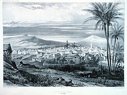
San Cristóbal de La Laguna in 1880 (Tenerife)

Caldera de Taburiente National Park (La Palma).

Garajonay (La Gomera)
(BBC/ 20111204)Canary Island volcano: A new island in the making?