-->

letztes Beben(Kanarische Inseln ( IGN)

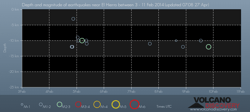
Bebenmap( El Hierro)

GPS deformation measure stations on El Hierro

MODVOLC/ Hawaii thermal alerts:

^
near real time thermal alert
for El Hierro, la Palma, Teneriffe and la Gomera ( updated once per week)
volcano discovery. com : Earthquake within 30 km radius around El Hierro:
-------
---------------
February 10- 16- 2014
January 15- 19- 2014
January 20- 27- 2014

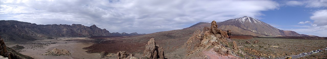
Mnt Teide ( Teneriffe)
VOLCANOES:
"Eruptions that shook the world"
a very interesting and freely avaible source how volcanoes work where you find all what you want to know about volcanoes
Sources of the volcanic activity at El Hierro ( since 2011):
Some may like to read a review on the volcanic activity below El Hierro in 2011:
Here is a data based report by earthquake .com- an excellent site regularly reporting (what you never get in the news) about Earthquakes and related volcanism
worldnews.com: Special environmental reports about the Canaries
Miscanellous:
Geschichte Teneriffas (deutsch)

Fataga ( Gran Canaria)
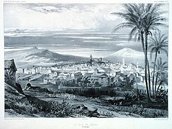
San Cristóbal de La Laguna in 1880 (Tenerife)

Caldera de Taburiente National Park (La Palma).

Garajonay (La Gomera)

(BBC/ 20111204)Canary Island volcano: A new island in the making?
:
:
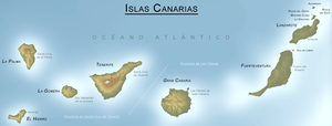
CANARY ISLANDS- ISLAS CANARIAS- KANARISCHE INSELN | |||||||||||||||||||||||||||||||||||||||||||||||||||||||||||||||||||||||||||||||||||||||||||||||||||||||||||||||||||||||||||||||||||||||||||||||||||||||||||||||||||||||
BLOG/ Startseite
| |||||||||||||||||||||||||||||||||||||||||||||||||||||||||||||||||||||||||||||||||||||||||||||||||||||||||||||||||||||||||||||||||||||||||||||||||||||||||||||||||||||||
| internal links > | START | HOME | SOLAR BLOG | VOLCANO WATCH | VOLCANO MAPS | external links > | IGN | AVCAN | AVCAN/ fb. | EMSC | GVP | NOAA |
Activity report here will ony follow, if new events take place. For other environmental reports, please visit the solar and terrestrial blog on my homepage
-------------
Microquake activity on the outer Northeastern Rim of the old Canary caldera continued and increased over the past days. Indeed this new evolution started in early October 2015 and marks likely another way the hot magma in the underground can burst free to find empty space where it still can run to and expand . Since the third activity phase has began in december 2013 and the old channels below El Hierro where sealed with the hard mantle lava by the eruption in 20111/ 12 the upcoming magma runs to where it finds lowest resistance . The canary island caldera indeed represents a extraordinary high resistance caldera created by the large coverage with sea sediments brought along by the strong sea currents around the islands.
comment on AVCAN facebook/ 20151020:
Seismicity in the eastern part of the archipelago with two earthquakes, one of magnitude 3.0 and another in 2.7.-the first of the earthquakes has been on the west coast of fuerteventura this morning at midnight last night, while the second has Been located north of Lanzarote in the area of the chinijo archipelago one hour and forty minutes past noon at a depth of 15 km which has been marked in almost all of the stations of the archipelago."
The two quakes measured M 2 .The last had M 3.0. which is the highest magnitude since more than one year. My Conclusion; the magmatic intrusion is still continuingand the pressure on the top sedimentg layer of the claldera between the islands and the volcanic systems seems now significantly to increase what is an indicator for an likely explosive eruption on the surface anytime in the next future- possibly already towards the end of the year or within the first half of 2016, depending only on the question whether the magmatic intrusion from the hot spot continues or not.
 < Tenerife- 20151020

 < Fuerteventura/ 2015102n

image above "sombrero of clouds and snow around Mount Teide on Tenerife (AVCAN)

Activity was rather calm throughout September 2015.
Now towards the end of September, two minor new SEPs ( solar proton events)occured on the Sun and were likely the cause for another increase in hot spot activites- in form new magma intrusions.

The proton flux values were rather low but meet a still active accumulation of protons and electrons form previous SEPs in the geomagnetic field -mainly the one that occured near summer soltice on June 18 and 21.that created a long term higher tension, that has weakened yet but has not really discharged yet
Seismic activities indicating new magma movements increased especially around Hawaii islands, around Etna on Sicil as well as below El Pinar at the South of El Hierro, where about the Canary hot spot is presently situated:
M 2.9 - ISLAND OF HAWAII, HAWAII - 2015-10-02 17:44:47 UTC
( just one of numerous quakes registered near Hawaii today)
M 2.6 - SICILY, ITALY - 2015-10-02 12:04:18 UTC
After October 01- 2015, also the earthquake swarm activities near Puerto Rico resumed/ increased again those occur since years and refer to tectonic movements within the Atlantic ocean- likely tensions caused by expanding magma rising up through the Midatlantic ridge as well as from the Canary hotspot:
M 3.4 - PUERTO RICO - 2015-10-02 13:35:04 UTC
-------------
OCTOBER 20- 2015:
Microquake activity on the outer Northeastern Rim of the old Canary caldera continued and increased over the past days. Indeed this new evolution started in early October 2015 and marks likely another way the hot magma in the underground can burst free to find empty space where it still can run to and expand . Since the third activity phase has began in december 2013 and the old channels below El Hierro where sealed with the hard mantle lava by the eruption in 20111/ 12 the upcoming magma runs to where it finds lowest resistance . The canary island caldera indeed represents a extraordinary high resistance caldera created by the large coverage with sea sediments brought along by the strong sea currents around the islands.
comment on AVCAN facebook/ 20151020:
Seismicity in the eastern part of the archipelago with two earthquakes, one of magnitude 3.0 and another in 2.7.-the first of the earthquakes has been on the west coast of fuerteventura this morning at midnight last night, while the second has Been located north of Lanzarote in the area of the chinijo archipelago one hour and forty minutes past noon at a depth of 15 km which has been marked in almost all of the stations of the archipelago."
The two quakes measured M 2 .The last had M 3.0. which is the highest magnitude since more than one year. My Conclusion; the magmatic intrusion is still continuingand the pressure on the top sedimentg layer of the claldera between the islands and the volcanic systems seems now significantly to increase what is an indicator for an likely explosive eruption on the surface anytime in the next future- possibly already towards the end of the year or within the first half of 2016, depending only on the question whether the magmatic intrusion from the hot spot continues or not.
| Evento | Fecha | Hora(GMT)* | Latitud | Longitud | Prof. (km) | Int. Máx. | Mag. | Tipo Mag. (**) | Localización | Info |
| 1350104 | 19/10/2015 | 13:39:45 | 29.6518 | -13.5819 | 3.2 | mbLg | ATLÁNTICO-CANARIAS | [+] | ||
| 1350065 | 19/10/2015 | 00:13:41 | 28.4841 | -14.2789 | 5 | II | 2.6 | mbLg | ATLÁNTICO-CANARIAS | [+] |
| 1349172 | 13/10/2015 | 00:02:46 | 28.0482 | -15.1605 | 27 | 1.8 | mbLg | ATLÁNTICO-CANARIAS | [+] | |
| 1348950 | 11/10/2015 | 07:04:12 | 28.7516 | -15.5302 | 30 | 1.7 | mbLg | ATLÁNTICO-CANARIAS | [+] | |
| 1348782 | 10/10/2015 | 13:56:45 | 28.1354 | -16.1458 | 20 | 2.1 | mbLg | ATLÁNTICO-CANARIAS | [+] |
TREMORS:
Indeed, tremiors incfreased significantly around Gran Canaria Fuerteventura and Lanzarote- another indicator that the quake activity around there is related to expanding hot magma< Tenerife- 20151020< Fuerteventura/ 2015102nimage above "sombrero of clouds and snow around Mount Teide on Tenerife (AVCAN)
OCTOBER 10- 2015:
Another shallow microquake was registered by IGN on 20151008 offshore west of Lanzarote island in the Northeast of Gran Canaria .It can`t be approved whether that quake was magmatic : I suppose it rather was magmatic and might indicate that magma is still continuously rising (whereever it can find lower resistance) within the old caldera between the islands resp its edges up towards the surface.
These microquakes might be the only indicator we have that can tell us, where about any surface eruption might occure within the next future: This might be the case about at end of 2015 or some months.later, so far as the magma intrusion from the hot spot South of El Hierro continues in the current pace) :
| Evento | Fecha | Hora(GMT)* | Latitud | Longitud | Prof. (km) | Int. Máx. | Mag. | Tipo Mag. (**) | Localización |
| 1348384 | 08/10/2015 | 03:51:52 | 28.9327 | -14.3921 | 4 | 1.8 | 4 | ATLÁNTICO-CANARIAS |
OCTOBER 02- 2015:
Activity was rather calm throughout September 2015.
Now towards the end of September, two minor new SEPs ( solar proton events)occured on the Sun and were likely the cause for another increase in hot spot activites- in form new magma intrusions.

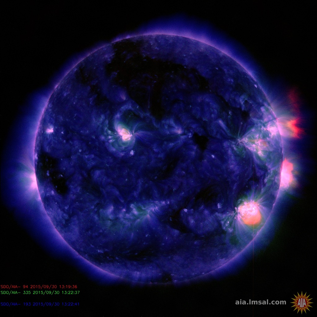
The SEP on September 30 (geomagnetic proton impact time: after 18 UTC) likely resulted along with a complex event of simultanous flares on the eastern solar limb, beginning after 15 UTC: (images. SDO):
The proton flux values were rather low but meet a still active accumulation of protons and electrons form previous SEPs in the geomagnetic field -mainly the one that occured near summer soltice on June 18 and 21.that created a long term higher tension, that has weakened yet but has not really discharged yet
Seismic activities indicating new magma movements increased especially around Hawaii islands, around Etna on Sicil as well as below El Pinar at the South of El Hierro, where about the Canary hot spot is presently situated:
M 2.9 - ISLAND OF HAWAII, HAWAII - 2015-10-02 17:44:47 UTC
( just one of numerous quakes registered near Hawaii today)
M 2.6 - SICILY, ITALY - 2015-10-02 12:04:18 UTC
After October 01- 2015, also the earthquake swarm activities near Puerto Rico resumed/ increased again those occur since years and refer to tectonic movements within the Atlantic ocean- likely tensions caused by expanding magma rising up through the Midatlantic ridge as well as from the Canary hotspot:
M 3.4 - PUERTO RICO - 2015-10-02 13:35:04 UTC
CANARY ISLANDS:
| Evento | Fecha | Hora(GMT)* | Latitud | Longitud | Prof. (km) | Int. Máx. | Mag. | Tipo Mag. (**) | Localización | Info |
| 1347301 | 01/10/2015 | 06:05:03 | 27.6934 | -17.9946 | 21 | 2.0 | mbLg | SW EL PINAR.IHI | [+] | |
| 1347290 | 30/09/2015 | 21:26:43 | 29.1713 | -15.9945 | 30 | 1.5 | mbLg | ATLÁNTICO-CANARIAS | [+] | |
| 1347196 | 30/09/2015 | 08:07:17 | 27.7542 | -18.1800 | 31 | 1.6 | mbLg | W FRONTERA.IHI | [+] | |
| 1347011 | 28/09/2015 | 22:45:21 | 27.6660 | -18.0779 | 10 | 2.0 | mbLg | SW EL PINAR.IHI | [+] | |
| 1347010 | 28/09/2015 | 22:43:41 | 27.7003 | -18.0175 | 12 | 1.9 | mbLg | W EL PINAR.IHI | [+] | |
| 1345870 | 23/09/2015 | 04:15:08 | 28.0864 | -16.1855 | 16 | 1.5 | mbLg | ATLÁNTICO-CANARIAS | [+] |
-----------------------
-----------------------
GOOGLE BLOG ARCHIVE
|
Seitenzahl: 03
|
| Latest Post |
| BLOG START/ NAVI |
useful links/ nützliche Links:
|
| EMSC |
| Global Volcanism Program |
| Facebook Seite der AVCAN |
| IGN (Spain) Serie El Hierro |
| Volcano-discovery.com |
| Earthquake- report. com |
MEDIEN:
|
KARTEN:
|
SOLAR (SAT)
|
SOLAR (info)
|
REAL TIME FEATURES:
(click on the images to enlarge them)
(click on the images to enlarge them)
Bebenmap( El Hierro)
GPS deformation measure stations on El Hierro
MODVOLC/ Hawaii thermal alerts:
^
near real time thermal alert
for El Hierro, la Palma, Teneriffe and la Gomera ( updated once per week)
volcano discovery. com : Earthquake within 30 km radius around El Hierro:
-------
---------------
previous posts those contain articles about the Canary volcanism in general:
February 10- 16- 2014
January 15- 19- 2014
January 20- 27- 2014
Mnt Teide ( Teneriffe)
related free online sources:
VOLCANOES:
"Eruptions that shook the world"
a very interesting and freely avaible source how volcanoes work where you find all what you want to know about volcanoes
Sources of the volcanic activity at El Hierro ( since 2011):
Some may like to read a review on the volcanic activity below El Hierro in 2011:
Here is a data based report by earthquake .com- an excellent site regularly reporting (what you never get in the news) about Earthquakes and related volcanism
worldnews.com: Special environmental reports about the Canaries
Miscanellous:
Geschichte Teneriffas (deutsch)

Fataga ( Gran Canaria)

San Cristóbal de La Laguna in 1880 (Tenerife)

Caldera de Taburiente National Park (La Palma).

Garajonay (La Gomera)
(BBC/ 20111204)Canary Island volcano: A new island in the making?