-->

letztes Beben(Kanarische Inseln ( IGN)

Bebenmap( El Hierro)

GPS deformation measure stations on El Hierro

MODVOLC/ Hawaii thermal alerts:

^
near real time thermal alert
for El Hierro, la Palma, Teneriffe and la Gomera ( updated once per week)
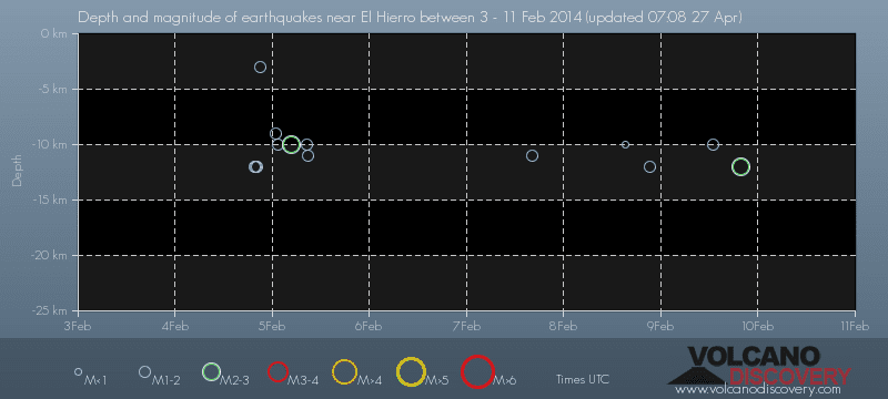
volcano discovery. com : Earthquake within 30 km radius around El Hierro:
-------
---------------
February 10- 16- 2014
January 15- 19- 2014
January 20- 27- 2014

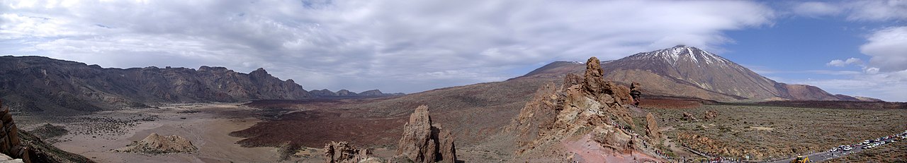
Mnt Teide ( Teneriffe)
VOLCANOES:
"Eruptions that shook the world"
a very interesting and freely avaible source how volcanoes work where you find all what you want to know about volcanoes
Sources of the volcanic activity at El Hierro ( since 2011):
Some may like to read a review on the volcanic activity below El Hierro in 2011:
Here is a data based report by earthquake .com- an excellent site regularly reporting (what you never get in the news) about Earthquakes and related volcanism
worldnews.com: Special environmental reports about the Canaries
Miscanellous:
Geschichte Teneriffas (deutsch)

Fataga ( Gran Canaria)
San Cristóbal de La Laguna in 1880 (Tenerife)

Caldera de Taburiente National Park (La Palma).

Garajonay (La Gomera)

(BBC/ 20111204)Canary Island volcano: A new island in the making?
:
:
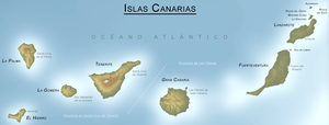
CANARY ISLANDS- ISLAS CANARIAS- KANARISCHE INSELN | |||||||||||||||||||||||||||||||||||||||||||||||||||||||||||||||||||||||||||||||||||||||||||||||||||||||||||||||||||||||||||||||||||||||||||||||||||||||||||||||||||||||||||||||||||||||||||||||||||||||||||||||||||||||||||||||||||||||||||||||||||||||||||||||||||||||||||||||||||||||||||||||||||||||||||||||||||||||||||||||||||||||||||||||||||||||||||||||||||||||||||||||||||||||||||||||||||||||||||||||||||||||||||||||||||||||||||||||||||||||||||||||||||||||||||||||||||||||||||||||||||||||||||||||||||||||||||||||||||||||||||||||||||||||||||||||||||||||||||||||||||||||||||||||||||||||||||||||||||||||||||||||||||||||||||||||||||||||||||||||||||||||||||||||||||||||||||||||||||||||||||||||||||||||||||||||||||||||||||||||||||||||||||||||||||||||||||||||||||||||||||
BLOG/ Startseite
| |||||||||||||||||||||||||||||||||||||||||||||||||||||||||||||||||||||||||||||||||||||||||||||||||||||||||||||||||||||||||||||||||||||||||||||||||||||||||||||||||||||||||||||||||||||||||||||||||||||||||||||||||||||||||||||||||||||||||||||||||||||||||||||||||||||||||||||||||||||||||||||||||||||||||||||||||||||||||||||||||||||||||||||||||||||||||||||||||||||||||||||||||||||||||||||||||||||||||||||||||||||||||||||||||||||||||||||||||||||||||||||||||||||||||||||||||||||||||||||||||||||||||||||||||||||||||||||||||||||||||||||||||||||||||||||||||||||||||||||||||||||||||||||||||||||||||||||||||||||||||||||||||||||||||||||||||||||||||||||||||||||||||||||||||||||||||||||||||||||||||||||||||||||||||||||||||||||||||||||||||||||||||||||||||||||||||||||||||||||||||||
| internal links > | START | HOME | SOLAR BLOG | VOLCANO WATCH | VOLCANO MAPS | external links > | IGN | AVCAN | AVCAN/ fb. | EMSC | GVP | NOAA |
Activity report here will ony follow, if new events take place. For other environmental reports, please visit the solar and terrestrial blog on my homepage
--------------------------

 < Gran Canaria/ 20151222


 < Tenerife/ 20151125
 < Gran Canaria / 20151125
-------------
--------------------------
ACTIVITY- DECEMBER 01- 31 2015:
December 22- 2015:
MOST SHALLOW MICROQUAKE SINCE DECEMBER 2013:
Microquake activity continued over the past week mainly around the mantle plume of the hot spot near El Hierro but also on varying places within the old Caldera between the island, mainly in its eastern part.
TREMORS meanwhile (over the past week) intensified on all islands, while the signals ( amplitudes) had been still rather low at time of the last update. The low tremor amplitudes, while microquake actvity increased obviously indeed (and as I assumed) was an indicator for new new and hotter magma coming up through the mantle plume , that would have less resistance and can easier melt the rock, thus causing less tremor signals. Signals on December 22 are- as usually-relatively strongest on Gran Canaria :
What was not known at the time of the last update ( below) was, that event 1358063 on December 14-2015 occured in depth of just 2 km below surface/ sea level, what marks the MOST SHALLOW microquake yet since the third activity phase began in December 2013, being part of a continuing evolution of single microquakes coming from time to time from a more shallow depth .This began already in 2013, when the most shallow quakes was still in 9 km depth, continuing since then with about one single quake all two month from one km less( 8km, then 7 km a. s. o.) .
2 km below sea level sets now new mark, to which height the mantle magma already has risen. The earth is a round body and as higher this magma gets as more space it also finds where it can run to, However-in that final state- before finally reaching the surface, the process seems logarithmically to slow down, while the magma current from below might even increase
While that magma cools down and hardens quicker and easier at its edges, such a hot spot volcano obviously is building up a new chamber with hot magma right in the middle of the expansion volume.
.
While that magma cools down and hardens quicker and easier at its edges, such a hot spot volcano obviously is building up a new chamber with hot magma right in the middle of the expansion volume.
.
| 1358063 | 14/12/2015 | 08:55:29 | 27.9533 | -18.1717 | 2 | 2.1 | mbLg | NW FRONTERA.IHI | [+] |
< Gran Canaria/ 20151222
The difference is. All prior shallow quakes occured near Mount Teide on Teneriffe while the last two ones now occured near El Hierro, what means that the shield volcanic feature there has currently less resistence than the volcanic construction of the Mount Teide massive. As the velocity , magma rises up with , gets slower towards the surface , the final break through might so still take 2 - 4 month and would be then a larger- but rather harmless and not explosive lava flow anywhere likely around the edges of the volcanic shield of El Hierro.
The other scenario is, that the mantle magma likely might at anytime and at this depth come in contact with water. This can immidiately create explosive mixtures and lead in the FIRST PHASE to an more or less strong explosive eruption with the possibility of pyroclastic emissions, The second part then would be rather a lava flow, possibly- accomponied by thick smoke, what was the typical scenario of the last known on Mount Tiede in the 18 century.
| Evento | Fecha | Hora(GMT)* | Latitud | Longitud | Prof. (km) | Int. Máx. | Mag. | Tipo Mag. (**) | Localización | Info |
| 1358868 | 21/12/2015 | 13:27:37 | 27.9997 | -16.7893 | 30 | 2.2 | mbLg | SW ADEJE.ITF | [+] | |
| 1358748 | 19/12/2015 | 15:12:13 | 27.7650 | -18.2214 | 35 | 2.8 | mbLg | W FRONTERA.IHI | [+] | |
| 1358735 | 19/12/2015 | 09:03:17 | 28.5012 | -14.1171 | 19 | II | 2.7 | mbLg | ATLÁNTICO-CANARIAS | [+] |
| 1358531 | 17/12/2015 | 20:57:21 | 27.7384 | -18.2355 | 34 | 2.8 | mbLg | W FRONTERA.IHI | [+] | |
| 1358440 | 17/12/2015 | 08:58:10 | 27.7060 | -18.0273 | 11 | 1.5 | mbLg | W EL PINAR.IHI | [+] | |
| 1358406 | 17/12/2015 | 05:54:10 | 27.7396 | -18.2211 | 34 | 2.5 | mbLg | W FRONTERA.IHI | [+] | |
| 1358405 | 17/12/2015 | 05:06:56 | 28.1445 | -16.2027 | 21 | 2.3 | mbLg | ATLÁNTICO-CANARIAS | [+] | |
| 1358400 | 16/12/2015 | 21:40:26 | 27.7563 | -18.2104 | 34 | 3.2 | mbLg | W FRONTERA.IHI | [+] | |
| 1358349 | 16/12/2015 | 13:16:15 | 27.8172 | -18.1495 | 30 | 2.6 | mbLg | NW FRONTERA.IHI | [+] | |
| 1358269 | 15/12/2015 | 22:33:42 | 27.8078 | -17.2610 | 12 | 2.4 | mbLg | ATLÁNTICO-CANARIAS | [+] |
---------------------
December 14- 2015:
Still increased magmatic activity- mainly offshore the South West of El Hierro near to La Fontera. Tremors however decreased since the last update on all islands, what also may be a sign of new and still very hot magma being present in the underground .
| Evento | Fecha | Hora(GMT)* | Latitud | Longitud | Prof. (km) | Int. Máx. | Mag. | Tipo Mag. (**) | Localización | Info |
| 1358063 | 14/12/2015 | 08:55:31 | 27.8959 | -18.1049 | 2.0 | mbLg | NW FRONTERA.IHI | [+] | ||
| 1358030 | 13/12/2015 | 15:40:52 | 28.7617 | -16.0670 | 39 | 2.3 | mbLg | ATLÁNTICO-CANARIAS | [+] | |
| 1358016 | 13/12/2015 | 03:47:11 | 27.7985 | -18.2646 | 34 | 1.9 | mbLg | W FRONTERA.IHI | [+] | |
| 1358014 | 13/12/2015 | 03:46:31 | 27.7619 | -18.2147 | 36 | 2.9 | mbLg | W FRONTERA.IHI | [+] | |
| 1357938 | 11/12/2015 | 15:41:11 | 27.7753 | -18.2170 | 33 | 1.6 | mbLg | W FRONTERA.IHI | [+] | |
| 1357908 | 11/12/2015 | 11:53:14 | 27.7876 | -18.2207 | 33 | 1.7 | mbLg | W FRONTERA.IHI | [+] | |
| 1357715 | 08/12/2015 | 21:41:24 | 28.5345 | -16.9109 | 2.5 | mbLg | ATLÁNTICO-CANARIAS | [+] | ||
| 1357512 | 06/12/2015 | 10:07:53 | 27.6749 | -18.2634 | 30 | 2.9 | mbLg | SW FRONTERA.IHI | [+] | |
| 1357511 | 06/12/2015 | 07:20:27 | 27.6334 | -18.2141 | 27 | 2.4 | mbLg | SW EL PINAR.IHI | [+] | |
| 1357472 | 05/12/2015 | 12:57:22 | 28.6703 | -14.2111 | 2.0 | mbLg | ATLÁNTICO-CANARIAS | [+] | ||
| 1357469 | 05/12/2015 | 11:22:25 | 28.1987 | -15.0422 | 5 | 2.0 | mbLg | ATLÁNTICO-CANARIAS | [+] | |
| 1357453 | 05/12/2015 | 02:30:16 | 28.1076 | -16.1551 | 22 | 2.1 | mbLg | ATLÁNTICO-CANARIAS | [+] | |
| 1357321 | 04/12/2015 | 09:35:57 | 27.6533 | -18.0308 | 10 | 2.7 | mbLg | SW EL PINAR.IHI | [+] |
^TREMORS on 20151215 ( Gran Canaria)
------------------------------------
20151202: Microquake activity continued with a major M 3.1 event on November 28 offshore the SW coast of El Hierro, near to la Frontera:
| Evento | Fecha | Hora(GMT)* | Latitud | Longitud | Prof. (km) | Int. Máx. | Mag. | Tipo Mag. (**) | Localización | Info |
| 1357177 | 02/12/2015 | 15:50:04 | 28.7340 | -16.9734 | 17 | 2.2 | mbLg | ATLÁNTICO-CANARIAS | [+] | |
| 1356688 | 28/11/2015 | 17:07:00 | 27.6947 | -18.1847 | 30 | 3.1 | mbLg | SW FRONTERA.IHI | [+] | |
| 1356570 | 28/11/2015 | 00:56:50 | 27.7231 | -18.1564 | 22 | 2.6 | mbLg | W FRONTERA.IHI | [+] | |
| 1356447 | 27/11/2015 | 06:51:03 | 28.1719 | -15.0495 | 30 | 2.0 | mbLg | ATLÁNTICO-CANARIAS | [+] | |
| 1356422 | 26/11/2015 | 19:29:39 | 28.4156 | -15.0885 | 30 | 2.3 | mbLg | ATLÁNTICO-CANARIAS | [+] | |
| 1355474 | 22/11/2015 | 17:18:25 | 27.7712 | -18.2564 | 30 | 2.6 | mbLg | W FRONTERA.IHI | [+] | |
| 1355459 | 22/11/2015 | 12:02:13 | 27.7645 | -18.2021 | 30 | 3.1 | mbLg | W FRONTERA.IHI | [+] | |
| 1355443 | 22/11/2015 | 09:17:57 | 28.4772 | -14.3583 | 18 | 2.2 | mbLg | ATLÁNTICO-CANARIAS | [+] | |
| 1355444 | 22/11/2015 | 09:08:51 | 28.4790 | -14.2797 | 30 | 2.1 | mbLg | ATLÁNTICO-CANARIAS | [+] |
---------------------------
ACTIVITY- NOVEMBER 01- 30 2015:
November 24- 2015:
Microquake activity is continuing on higher level also in the second half of November 2015. The epicenter of the most quakes is near to the hot spot resp. within mantle plume below El Hierro. At the same time the harmonic tremors on all islands increased in magnitude and show a muster as never seen since the third activity phase began in December 2013. The earth is a round body- and so- as closer mantle magma comes to the surface as more space it has to expand . Out of that reason: Allthough the magmatic intrusion from the hot spot may continue at the same pace ( same amount of magma per hour) the magma intrusion JUST SEEMS to slow down as more it gets close to the surface.
Nevertheless, resp out of these data I strongly believe, that the magma that has assembled within the Canary caldera since the new activity phase began in Dec 2013 comes more and more close r to a surface eruption, that may already occure until the end of 2015 or in the first months of 2016. ( this prediction is only valid if magma intrusion should NOT COME TO AN HALT UNTIL THEN!!)
Nevertheless, resp out of these data I strongly believe, that the magma that has assembled within the Canary caldera since the new activity phase began in Dec 2013 comes more and more close r to a surface eruption, that may already occure until the end of 2015 or in the first months of 2016. ( this prediction is only valid if magma intrusion should NOT COME TO AN HALT UNTIL THEN!!)
| Evento | Fecha | Hora(GMT)* | Latitud | Longitud | Prof. (km) | Int. Máx. | Mag. | Tipo Mag. (**) | Localización | Info |
| 1355474 | 22/11/2015 | 17:18:25 | 27.7712 | -18.2564 | 30 | 2.6 | mbLg | W FRONTERA.IHI | [+] | |
| 1355459 | 22/11/2015 | 12:02:13 | 27.7645 | -18.2021 | 30 | 3.1 | mbLg | W FRONTERA.IHI | [+] | |
| 1355443 | 22/11/2015 | 09:17:57 | 28.4772 | -14.3583 | 18 | 2.2 | mbLg | ATLÁNTICO-CANARIAS | [+] | |
| 1355444 | 22/11/2015 | 09:08:51 | 28.4790 | -14.2797 | 30 | 2.1 | mbLg | ATLÁNTICO-CANARIAS | [+] | |
| 1355402 | 21/11/2015 | 04:00:20 | 27.7660 | -18.2339 | 30 | 2.3 | mbLg | W FRONTERA.IHI | [+] | |
| 1355346 | 20/11/2015 | 15:45:59 | 27.7081 | -18.2606 | 27 | 1.6 | mbLg | W FRONTERA.IHI | [+] | |
| 1354997 | 18/11/2015 | 22:44:24 | 27.7085 | -18.2379 | 30 | 2.2 | mbLg | W FRONTERA.IHI | [+] | |
| 1354934 | 18/11/2015 | 15:06:50 | 27.7594 | -18.2033 | 30 | 2.9 | mbLg | W FRONTERA.IHI | [+] | |
| 1354669 | 18/11/2015 | 06:06:59 | 29.0305 | -13.7983 | 2.0 | mbLg | NW YAIZA.ILZ | [+] | ||
| 1354660 | 18/11/2015 | 04:44:07 | 27.7755 | -18.2489 | 30 | 2.5 | mbLg | W FRONTERA.IHI | [+] | |
| 1354438 | 17/11/2015 | 06:21:10 | 27.9876 | -18.1650 | 2.0 | mbLg | NW FRONTERA.IHI | [+] | ||
| 1354419 | 16/11/2015 | 23:03:20 | 27.7594 | -18.2592 | 30 | 2.3 | mbLg | W FRONTERA.IHI | [+] | |
| 1354410 | 16/11/2015 | 19:59:58 | 27.7517 | -18.2594 | 31 | 2.5 | mbLg | W FRONTERA.IHI | [+] | |
| 1354306 | 16/11/2015 | 11:14:55 | 26.8737 | -14.3384 | 30 | 3.7 | mbLg | ATLÁNTICO-CANARIAS | [+] | |
| 1354272 | 16/11/2015 | 05:01:34 | 28.0866 | -16.1753 | 24 | 1.5 | mbLg | ATLÁNTICO-CANARIAS | [+] | |
| 1354259 | 16/11/2015 | 03:15:46 | 27.7786 | -18.2552 | 31 | 2.2 | mbLg | W FRONTERA.IHI | [+] | |
| 1354229 | 15/11/2015 | 12:38:48 | 27.7944 | -18.2225 | 37 | 2.5 | mbLg | W FRONTERA.IHI | [+] | |
| 1354228 | 15/11/2015 | 12:07:12 | 28.4200 | -16.5719 | I-II | 2.3 | mbLg | W PUERTO DE LA CRUZ.ITF | [+] |
TREMORS:
< Tenerife/ 20151125< Gran Canaria / 20151125-----------------------
November 15- 2015:
Microquake activity arpound the Canary hot spot is still elevated aand even some higher as in Octrober 2015. Due to my statistic reserarch this is related again to some minor but effective proton events on the sun resp trhe subsequent electron accumulation following each SEP.
| Evento | Fecha | Hora(GMT)* | Latitud | Longitud | Prof. (km) | Int. Máx. | Mag. | Tipo Mag. (**) | Localización | Info |
| 1353957 | 13/11/2015 | 06:39:19 | 27.6247 | -18.0218 | 11 | 1.9 | mbLg | SW EL PINAR.IHI | [+] | |
| 1353907 | 12/11/2015 | 14:20:32 | 27.7060 | -18.0026 | 14 | 1.8 | mbLg | W EL PINAR.IHI | [+] | |
| 1353888 | 12/11/2015 | 12:47:03 | 27.6927 | -18.0062 | 14 | 2.8 | mbLg | SW EL PINAR.IHI | [+] | |
| 1353567 | 10/11/2015 | 11:38:26 | 28.6204 | -13.8993 | 28 | II | 3.1 | mbLg | E LA OLIVA.IFV | [+] |
| 1353347 | 08/11/2015 | 23:08:58 | 28.7587 | -16.0949 | 30 | 2.1 | mbLg | ATLÁNTICO-CANARIAS | [+] | |
| 1353153 | 07/11/2015 | 20:01:13 | 27.7011 | -18.0559 | 12 | III | 3.8 | mbLg | W EL PINAR.IHI | [+] |
| 1353015 | 07/11/2015 | 06:53:22 | 27.6822 | -18.0080 | 6 | 1.6 | mbLg | SW EL PINAR.IHI | [+] | |
| 1353013 | 07/11/2015 | 04:40:41 | 28.0939 | -16.1463 | 29 | 2.0 | mbLg | ATLÁNTICO-CANARIAS | [+] | |
| 1352903 | 06/11/2015 | 11:38:25 | 28.0983 | -16.2410 | 26 | 2.1 | mbLg | ATLÁNTICO-CANARIAS | [+] | |
| 1352870 | 06/11/2015 | 08:18:50 | 27.7801 | -18.0066 | 13 | 1.6 | mbLg | NW FRONTERA.IHI | [+] | |
| 1352827 | 06/11/2015 | 04:01:00 | 27.6214 | -16.2530 | 30 | II | 3.7 | mbLg | ATLÁNTICO-CANARIAS | [+] |
| 1352778 | 05/11/2015 | 20:56:47 | 27.6899 | -18.0457 | 14 | 2.1 | mbLg | W EL PINAR.IHI | [+] | |
| 1352728 | 05/11/2015 | 09:43:45 | 27.6776 | -18.0643 | 21 | 1.9 | mbLg | SW EL PINAR.IHI | [+] |
the most shallow microquake are still measure in a depth of around 6 km.
Harmonic Tremors where rather low at the time of this update, but are still present throughout the islands: Values measured on today`s Nov 15 were relatively highest on Gran Canaria:

OTHER SEP EFFECTS:
On November 12, the integral electron flux rose high above tresholds and > 2.0 Me Electrons exceeded 10.000 pfu. these high energetic electrons have the capability to heat up the earth mantle ( causing higher volcanic activities) as they also lead to dramatic changes and paradox climate/ weather patterns with currently high temperatures and drought on the northern Hemisphere. As these electron accumulations especially heats up of the Northern polar regions , the heat exchange over the sea currents is weakened, thus the temperature exchange between North and South happens/ shifts more through the athmosphere what ios acomponied by circum polar wind and storm systems and two typical latitudenal line where the two temperature streams- a coild form the North and a warm form the equator- meet each other causing heavy weathers and even regularly floodings
-------------
GOOGLE BLOG ARCHIVE
|
Seitenzahl: 03
|
| Latest Post |
| BLOG START/ NAVI |
useful links/ nützliche Links:
|
| EMSC |
| Global Volcanism Program |
| Facebook Seite der AVCAN |
| IGN (Spain) Serie El Hierro |
| Volcano-discovery.com |
| Earthquake- report. com |
MEDIEN:
|
KARTEN:
|
SOLAR (SAT)
|
SOLAR (info)
|
REAL TIME FEATURES:
(click on the images to enlarge them)
(click on the images to enlarge them)
Bebenmap( El Hierro)
GPS deformation measure stations on El Hierro
MODVOLC/ Hawaii thermal alerts:
^
near real time thermal alert
for El Hierro, la Palma, Teneriffe and la Gomera ( updated once per week)
volcano discovery. com : Earthquake within 30 km radius around El Hierro:
-------
---------------
previous posts those contain articles about the Canary volcanism in general:
February 10- 16- 2014
January 15- 19- 2014
January 20- 27- 2014
Mnt Teide ( Teneriffe)
related free online sources:
VOLCANOES:
"Eruptions that shook the world"
a very interesting and freely avaible source how volcanoes work where you find all what you want to know about volcanoes
Sources of the volcanic activity at El Hierro ( since 2011):
Some may like to read a review on the volcanic activity below El Hierro in 2011:
Here is a data based report by earthquake .com- an excellent site regularly reporting (what you never get in the news) about Earthquakes and related volcanism
worldnews.com: Special environmental reports about the Canaries
Miscanellous:
Geschichte Teneriffas (deutsch)

Fataga ( Gran Canaria)

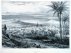
San Cristóbal de La Laguna in 1880 (Tenerife)

Caldera de Taburiente National Park (La Palma).

Garajonay (La Gomera)
(BBC/ 20111204)Canary Island volcano: A new island in the making?